
Places & Travel
HardMaps and Navigation Crossword
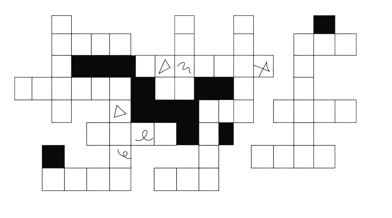
Category: Places & TravelDifficulty: Medium15 × 11
Tuesday, September 22

Leaderboard Ad Unit
Enter one letter per square. Answers run Across or Down. Omit spaces and accents; any special spelling convention is stated in the clue. This is a freeform themed grid, so some letters are not crossed.
MPU / Sidebar Ad Unit

About This Theme
A map is a set of decisions about how to represent a place. This crossword explores the words that let you read those decisions: symbols, directions, measurements and reference lines. Several clues describe something drawn on a map, while others concern the tools used beside it. Think about the question each feature answers. Does it tell you where north is, how high the ground rises, or how far a short line on paper represents?
Clues
Across
- 1Instrument with a magnetic needle used to find direction (7)
- 6Relationship between map distance and real-world distance (5)
- 8Network of reference lines on a map (4)
- 9Angular position north or south of the equator (8)
- 10Direction conventionally placed at the top of many maps (5)
- 11Angular position east or west of a reference meridian (9)
- 12Map line connecting points of equal elevation (7)
Down
- 2Line of longitude running between the poles (8)
- 3Bound collection of maps (5)
- 4Direction expressed as an angle in navigation (7)
- 5Part of a map explaining its symbols (6)
- 7Reference circle for zero degrees latitude (7)
Answers and Explanations
After Your Solve
LEGEND and SCALE solve different problems. The legend explains what symbols mean, while the scale relates map distance to distance on the ground. LATITUDE and LONGITUDE provide another pair: one measures position north or south, the other east or west. CONTOUR lines bring height into a flat drawing. Notice how much of the puzzle depends on relationships rather than place-name trivia. Once those relationships are clear, a map becomes easier to interpret even when the destination itself is unfamiliar.
- 1 acrossCOMPASS
A magnetic compass responds to Earth's magnetic field.
- 6 acrossSCALE
Scale lets a short drawn distance represent a larger one.
- 8 acrossGRID
A grid supports locating positions.
- 9 acrossLATITUDE
Latitude differs from east-west position.
- 10 acrossNORTH
The convention is common but not universal.
- 11 acrossLONGITUDE
Longitude is measured relative to a chosen meridian.
- 12 acrossCONTOUR
Contour lines describe the shape of the terrain.
- 2 downMERIDIAN
A meridian follows a north-south direction.
- 3 downATLAS
An atlas groups maps in one reference work.
- 4 downBEARING
A bearing specifies a direction rather than a distance.
- 5 downLEGEND
Legend is also called a map key.
- 7 downEQUATOR
The equator is the starting reference for latitude.
Further Reading
- Theme referenceusgs.gov
More Puzzles
Places & Travel
EasyNational Parks Crossword
Play National Parks Crossword
Tomorrow's puzzle is already being written.
Membership is free, we send one email a morning, and you can leave with one click.